| GISdevelopment.net ---> AARS ---> ACRS 1999 ---> Poster Session 6 |
Comparison study on rainrall
retrieval Algorithm: model simulation and armar data
Jinli
Liu, Zhehu Cui, Ling Zhang,
Xiankang Dou, Daren Lu
LAGEO, Institute of Atmospheric Physics, Chinese Academy of Sciences
Beijing 100029, CHINA
Keyword: Rainfall remote sensing, SSM/I, AMSR,
TOGA COARE, Microwave radiative transfer model
LAGEO, Institute of Atmospheric Physics, Chinese Academy of Sciences
Beijing 100029, CHINA
Abstract
Although space-borne Microwave (MW) radiometers have been actively used for global rainfall estimation, to date the retrieval accuracy of rainfall rate still can't meet the requirement of operational use and research, one of the main reasons is the highly complexity and rapid variation of the vertical structure of precipitating cloud. For improving the accuracy of retrieval rainfall rate, a proper cloud structure should be chosen.
In this paper, By using ARMAR airborne radar-radiometer data, which was obtained in TOGA COARE IOP, and the dynamic cloud model we established two kinds of precipitating cloud models: convective and stratified precipitating cloud with vertical structure. Based on these cloud models the simulation relationship of Tb-R (brightness temperature versus rainfall rate) were compared with the real observation of ARMAR’s data. Also, several retrieval algorithms of rainfall rate are compared based on these cloud models.
Introduction
Rainfall distribution over global and regional scales plays important role in research and application for climate change and global water cycle within the ocean-land-atmosphere system. Satellite-borne microwave (MW) radiometry, such as DMSP’s SSM/I has been proved as a powerful tool for global rainfall estimation. Although it is successful in revealing global pattern and annual variation of global rainfall distribution, there is still big discrepancy in the accuracy and correlation of retrieval rainfall to real rainfall.
For improving the retrieval accuracy of rainfall rate, establishment of precipitating cloud model is also a key step. Tropical region covers big part of global oceans, remote sensing of rainfall in this area is of significance. There are mainly two different kinds of rainfall in this area, i.e., convective and rather homogeneous stratified rainfall. We analyzed the ARMAR[ Durden et al 1994] airborne radar/radiometer observation data which was measured over equatorial Pacific Ocean during TOGA /COARE Intensified Observation Period ( IOP ) and established stratified and convective cloud models. With these two cloud models, MW radiative transfer (R-T) simulations were made by a vector R-T code. All channels of SSM/I and AMSR were simulated with various rainfall rates. In the following sessions, two precipitating cloud models are introduced and validated; For extending the algorithm derived from SSM/I data to AMSR data, the R-T simulations have been made with two cloud models by changing the corresponding MW frequencies.
Models
Vertical structure of precipitating clouds
There are basically two kinds of precipitating clouds in tropical area: convective cloud and stratified cloud. Here we used the ARMAR radar/radiometer data observed during TOGA COARE IOP as the basis of cloud model. Airborne radar observed vertical structure of radar reflectivity Ze and the MW radiometer observed the brightness temperature of underneath cloud-ocean surface system. The observation revealed very clear stratified characteristics with brightband as well as relatively horizontal homogeneity of precipitating cloud. With these data we made statistics of Ze profiles and produced an average (typical) profile, which may represent as basis for R-T simulation. Since the data set did not contain the phase information except the brightband showing the height of 0°c level, we used the simulation output of a cloud dynamical model developed by Hu & Yan (1986), and used radio sounding data and ocean surface condition in TOGA COARE period as the input, the output contained vertical structure of raindrops, cloud droplets as well as various kind of ice particles. Based on composition of radar observation and cloud model output of microphysical structure, we established stratified and convective precipitating cloud models respectively (see Fig.1 and Fig.2).
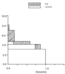
Fig.1 Stratified cloud model
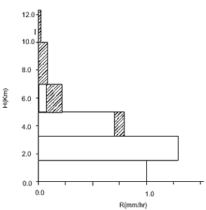
Fig2. Convective cloud model
Radiative Transfer Model
In present simulation vector R-T model developed by Evans [Evans & Stephens 1995] was used. Simulations were made for the following situations: Range of rainfall rate: 0 – 50 mm/hr, MW channel: 13.8 GHz, all 7 channels of SSM/I, 10 channels of ADEOSII AMSR, ground surface: calm ocean, and Marshall-Palmer spectra were used for both liquid and ice particles. In simulation, both the relation between Tb (brightness temperature) and R (rainfall rate) and between Tb and TWC (total column water content) were concerned.
Results
Comparison study of Tb-R relations
The effectiveness of cloud models we established is validated with the comparison of the real observation of Tb-R (brightness temperature versus rainfall rate) and radiative transfer calculation with model structure and rainfall rate as input. Fig.3 and Fig.4 show the comparison results. Tb-R scatterogram is the observed real data obtained from ARMAR data. Tb is the observed brightness temperature from airborne radiometer and the rainfall rate was derived from corresponding radar reflectivities with attenuation correction [Dou et al 1997]. The solid curves are the simulation results based on the model structures with radiative transfer model. It can be seen that the tendency of real observation and model simulation are rather consistent. It is indicated that these cloud models can be used as the basis for study of algorithm retrieval rain rate with other MW sensors from R-T model simulation
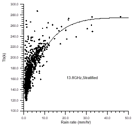
Fig.3 Tb-R relationship in simulation and real observed data for stratified cloud. Solid lines are the simulation result; dots are the observed data.
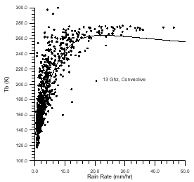
Fig.4 same as Fig.3 but for convective cloud
Simulation Results
Retrieval methods of rainfall rate usually depend on empirical and/or physical methods. When we have enough representative data of collocated satellite observation, Tbi, with surface rainfall measurement, empirical formula could be established. We have established this kind of retrieval formula for SSM/I ( LU et al , 1998). When we have to extend the existed formulae to new combination of MW channels, such as AMSR on ADEOS II, new retrieval formulae relating Tbi sets of AMSR to surface rainfall rate should be established. Since there are no observation existed, we have to depend on the simulated results of MW brightness temperature from certain precipitating cloud model. If the precipitating cloud model is valid for retrieval with existed observation, this precipitating cloud model will be used as the basis for retrieval of rainfall rate with new MW sensors.
As mentioned above, the established vertical structure cloud models have been validated with existed observation by ARMAR data at 13.8 GHz (see 3.1). For extending the retrieval formulae obtained with SSM/I to AMSR, we need to investigate them by radiative transfer model.
Based on the analysis of Tbi-R relation of SSM/I data and surface rainfall rate data provided by NASDA, Japan, LU et al. (1998) have proposed a probability pairing method for retrieving rainfall rate with SSM/I data. First, the relation of Rl (we call Rain index) and Tbi (combined brightness temperature) was established. Which is
Rl = 28.66 + 0.2845ln(Tbb19v-Tb19h) + 0.5455ln(Tb22v -180) – 6.066ln(Tb85v -T b19v +100) (1)
After probability pairing, i.e. conducted the SSM/I and collocated radar-rain guage data, we made empirical fitting for R (rain rate) and Rl (rain index) relationship from pairing curve:
R = 0.0 (Rl <1.41)
R = -1.01122 + 0.224002Rl +0.364442Rl2-0.0192194Rl3 (1.41<Rl<12)
R = -23.3259 + 5.50855Rl - 0.137673Rl2 (Rl>12) (2)
For comparison study, Rf , scattering index proposed by Ferraro(1995) is chosen as rain index, which is:
Rf = - 174.4 + 0.72Tbb19v + 2.439 Tb22v – 0.00504T2b22v - Tb85v (3)
Then using probability pairing as above, we obtained the relation of R-Rf :
R = 0.0 (Rf<1.94)
R = -0.0470175 + 0.0365984Rf +0.00125964Rf2 (1.94<Rf<120)
R = 33.7097 - 0.496671Rf -0.000356007Rf2 (Rf>120) (4)
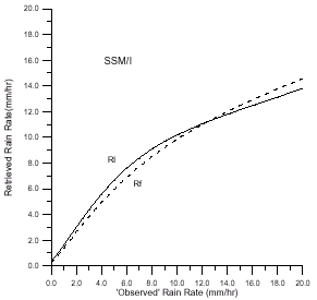
Fig.5: Relationship of retrieved rain rate and ‘observed’ rain rate by using SSM/I data.
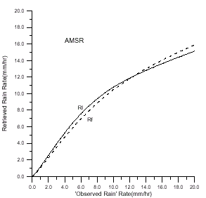
Fig. 6 same as Fig.5 but for AMSR data.
For extending the retrieval method to AMSR data, we choose the adjacent channels of AMSR instead of the channels of SSM/I which were used in formulae (1)-(4), i.e. we chose 18.7, 23.8, 36.5, 89.0 GHz of AMSR channels instead of 19.35, 22.235, 37.0 , 85.5 GHz of SSM/I data respectively.
By using these formulae and radiative transfer model with the established cloud models we may obtain the R-Tbi relationship. Fig.5 shows the comparison results of the ‘observed’ and retrieval rain rate with Rl and Rf as rain index for SSM/I in stratified precipitating cloud . It can be found that the agreement between retrieval and ‘observe’ rainfall rate are acceptable; Also, the simulation retrieval results have good consistence for chosen Rl and Rf as rain index in probability pairing method. Fig.6 is the results of AMSR data. Comparing Fig.5 and Fig.6, it can be seen that Tbi-R relation for AMSR data is better than SSM/I data. In this point, it means that the probability paring method derived from SSM/I data may be extended to the AMSR data.
Conclusion and Discussion
- Based on the TOGA/COARE airborne radar-radiometer observation and cloud dynamic model two vertical structure cloud models were established for MW remote sensing of rainfall rate. These models were validated by comparison the simulation and real observed data at 13.8 GHz.
- Probability pairing method derived from SSM/I data and ground truth rain rate data were extend to AMSR data by a vector radiative transfer model with changing the adjacent channels and the established cloud model. The computation results revealed that the Tbi – R relationship for SSM/I and AMSR data are acceptable. It seems that the probability method derived from SSM/I can be extend to AMSR and both Rl & Rf can be chosen as the rain index.
- For next step of MW retrieved of rainfall, we are searching for the method, which relating Tbi with vertical structure of cloud, such as ice content, mixed layer water content, water content in lowest layer. In fact, rainfall rate is closely related to the liquid water content in the lowest layer of the atmosphere, and the space-borne observed brightness temperature is closely related to the total water content of precipitating cloud and ice particle content at upper layer, depending on MW frequencies.
This project is supported by the National Natural Science Foundation of China (No.49885001 & 49705058), Part of this work is supported by a contract of NASDA, Japan, no. AMSR RA-0017 for ADEOS II AMSR retrieval algorithm development.
References
- Dou X.K., J. Testud, P. Amayene 1997: The Study of the Space-borne Rain Radar Rainfall Rate Retrieval Algorithms by Simulations, Chinese Sci. Bull., Vol .42, No.3,292-295
- Durden,S.L., E.Im, F.K.Li, W.Ricketts, A. Tanner, and W. Wilson 1994, ARMAR:An Airborne Rain-mapping Radar, J.Atmos. Oceanic Technol., vol.11: 727-737
- Evans, K. F., and G..L. Stephens, 1995: Microwave Radiative through Clouds Composed of Realistically Shaped Ice Crystals. Part II: Remote Sensing of Ice Clouds. J. Atmos. Sci., vol.52, 2058-2072.
- Ferraro,R.R. and Marks G. 1995: The Development of SSM/I Rain-Rate Retrieval Algorithms Using Ground-Based Radar Measurements. J. Atmos. Oceanic Technol., 12, 755-770
- HU ZhiJin & YAN Caifan (1986): Numerical Simulation of Microphysical Processes in Stratiform Cloud: Microphysical Model, J. f Academy of Meteor. Sci., S.M.A.,CHINA (1),37-58
- LU Daren et al 1998: New Method for Retrieval of Rainfall Rate over Ocean with SSM/I data, Proceedings of SPIE ’Microwave Remote Sensing of the Atmosphere and Environment’ Vol.3503,14-19